Magnitude 7.7 Earthquake Strikes Flores Sea Near Ende, Indonesia
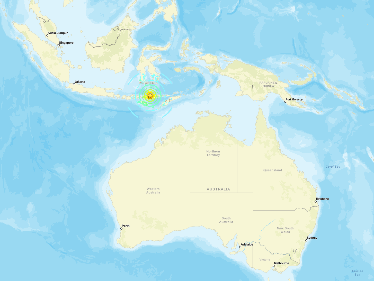
INDONESIA — A magnitude 7.7 earthquake struck the Flores Sea on August 15 at 5:58 a.m. local time (9:58 p.m. UTC on August 14) at a depth of 6.2 miles (10 km).
The shallow crustal event was centered at 8.310 degrees S, 121.352 degrees E, 42 miles (68 km) north-northwest of Ende on Flores Island in East Nusa Tenggara (NTT).
The United States Geological Survey classified the event as reviewed. The rupture occurred as reverse faulting within the overriding Sunda plate amid convergence between the Australia and Sunda plates. Approximately 1.17 million people experienced strong shaking (MMI VI) or higher.
Indonesia’s Meteorology, Climatology, and Geophysics Agency (BMKG) issued a tsunami early warning for coastal areas of East Nusa Tenggara (NTT), West Nusa Tenggara (NTB), South Sulawesi, and Southeast Sulawesi. Aftershocks are underway.
BMKG later recorded observed tsunami waves at multiple coastal stations, with the highest reading 0.94 m at Maurole.
The mainshock was followed within the first hour by several larger aftershocks in the same region, including events of magnitude 5.9, 6.1 and higher recorded by USGS and BMKG.
Key Seismic Parameters
-
Magnitude: Mw (Magnitude) 7.7 (USGS) / M 7.7 (BMKG)
-
Depth: 6.2 miles (10 km), shallow crustal; BMKG lists 9.3 miles (15 km)
-
Epicenter coordinates: 8.310°S 121.352°E
-
Time: 5:58 a.m. local time (9:58:21 p.m. UTC on August 14)
-
Location: 42 miles (68 km) north-northwest of Ende, Flores Sea, East Nusa Tenggara, Indonesia
-
Focal Mechanism: reverse (thrust) faulting; nodal planes strike 283° dip 64° rake 104° and strike 73° dip 29° rake 63°
-
Tectonic Setting: intraplate reverse faulting within the Sunda plate, approximately 217 miles (350 km) north of the Sunda Trench
-
PAGER Alert Level: Yellow
-
ShakeMap peak intensity: MMI VIII (Severe)
-
Tsunami Warning Status: BMKG early warning (PD-2) active for NTT, NTB, South Sulawesi, and Southeast Sulawesi coasts; observed waves recorded at multiple stations
Depth and Energy Release
Depth controls how much energy reaches the surface and whether a submarine rupture can displace the water column. At 6.2 miles (10 km) the energy released by this Mw (Magnitude) 7.7 event was concentrated near the seafloor, producing high peak ground accelerations close to the epicenter and creating conditions favorable for tsunami generation.
A depth of exactly 10 km is commonly a preliminary default value that can be revised once additional waveform data are incorporated.
A revision to greater depth would reduce both surface intensity and tsunami potential; a shallower revision would increase both. The BMKG depth of 9.3 miles (15 km) remains in the high-risk shallow band for water-column displacement.
Shaking and Intensity
USGS ShakeMap indicates a peak intensity of MMI VIII (Severe: heavy damage to poorly built structures, moderate damage to ordinary buildings, felt by everyone).
Approximately 56,000 people experienced MMI VIII, 420,000 experienced MMI VII (Very Strong), and 1.17 million experienced MMI VI (Strong).
Cities inside the strong-shaking zone include Ende (population approximately 87,000 per USGS exposure data) at MMI VI, Maumere (104,000) at MMI VI, and Ruteng (54,000) at MMI VI. Makassar, more than 180 miles (290 km) west, registered MMI V. Intensity decays rapidly with distance in this setting, but sedimentary basins on Flores and nearby islands can locally amplify shaking.
Tsunami Assessment
An earthquake generates a tsunami when vertical seafloor displacement lifts or drops the overlying water column. Three conditions control the risk: shallow depth (under roughly 31 miles (50 km)), a thrust or reverse mechanism that produces vertical motion, and sufficient magnitude (typically Mw (Magnitude) 7.0 and above for significant waves).
This event meets all three criteria. The Pacific Tsunami Warning Center had not issued a basin-wide bulletin by 11:46 p.m.
UTC on August 14. Indonesia’s BMKG, responsible for local warnings, issued a tsunami early warning (PD-2) covering coastal segments of East Nusa Tenggara, West Nusa Tenggara, South Sulawesi, and Southeast Sulawesi, with estimated arrival times beginning within minutes of origin for the nearest northern Flores coasts.
BMKG subsequently reported observed sea-level anomalies at coastal stations: 0.38 m at Kawapante (5:16 a.m. local), 0.25 m at Flores Timur (5:24 a.m. local), 0.94 m at Maurole (5:27 a.m. local), and 0.14 m at Bakalang (5:41 a.m. local).
Additional readings included 0.19 m at Sikka, 0.36 m at Labuan Bajo, and 0.17 m at Dompu. India’s Indian National Centre for Ocean Information Services (INCOIS) stated there was no tsunami threat to India from this event.
Impact and Damage
No confirmed casualty or structural-damage figures had been released by Indonesia’s National Disaster Management Agency (BNPB) or provincial authorities as of 11:46 p.m. UTC on August 14. USGS PAGER estimates place the event in the Yellow alert band, indicating some casualties and damage are possible and the impact should remain relatively localized. Estimated economic losses are less than 1 percent of Indonesia’s GDP.
Ground-failure models show significant landslide potential in the epicentral area and limited liquefaction potential. BNPB and provincial authorities had released no verified fatality or injury totals as of 11:46 p.m. UTC on August 14.
Population Exposure
USGS PAGER population exposure by shaking band:
-
MMI VIII (Severe): 56,000
-
MMI VII (Very Strong): 420,000
-
MMI VI (Strong): 1,171,000
-
MMI V (Moderate): 2,712,000
-
MMI IV (Light): 11,167,000
Major population centers inside the felt area include Makassar (MMI V), Bima, Maumere, and Ende. The epicentral region is a mix of coastal towns and rural highland communities on Flores and nearby islands.
Aftershock Assessment
USGS notes that aftershocks, some potentially capable of strong shaking, may follow. BMKG real-time listings already show multiple events of magnitude 4.0 to 6.2 in the Flores region within the first two hours.
Bath’s Law indicates the largest aftershock is typically about 1.2 magnitude units smaller than the mainshock, placing a plausible upper bound near Mw (Magnitude) 6.5.
No formal USGS aftershock probability forecast product had been issued as of 11:46 p.m. UTC on August 14. Historical sequences on the Flores back-arc system have produced elevated seismicity lasting days to weeks.
BMKG and other networks recorded a magnitude 6.2 event shortly after the mainshock and a magnitude 5.6 aftershock approximately 20 minutes later near the same area, along with numerous smaller events continuing through the morning of August 15. USGS and BMKG both recorded multiple aftershocks in the magnitude 5.9–6.2 range within the first hour of the mainshock.
Official Statements
-
BMKG stated: “Tsunami Early Warning for NTT, South Sulawesi, NTB, and Southeast Sulawesi” and later updated: “Update to Early Warning: Tsunami resulting from the magnitude 7.7 earthquake (30 km northeast of Mbay-Nagekeo-NTT) has been detected at ... Maurole-Ende (5:27 a.m. local time) at 0.94 m.”
-
INCOIS stated there was no tsunami threat to the Indian coastline from this event.
-
USGS published the reviewed Mw (Magnitude) 7.7 solution, W-phase moment tensor, ShakeMap, and PAGER Yellow alert. No formal aftershock-forecast product had been issued as of 11:46 p.m. UTC on August 14.
Full Report & Analysis
The full report includes expert analysis and risk assessment.
Full Report & Analysis →