Madagascar: Tropical Cyclone GEZANI Intensifies to Category 4 and Makes Landfall Near Toamasina
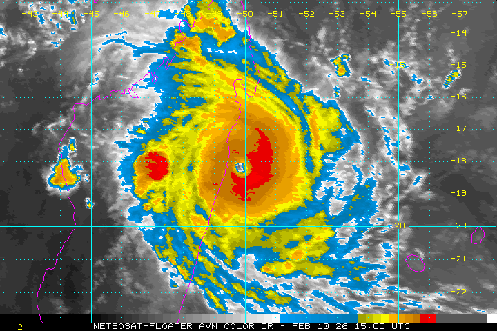
MADAGASCAR - Tropical Cyclone GEZANI intensified rapidly to Category 4 strength before making landfall near Toamasina on February 10, with sustained winds of 205 km/h (127 mph) and gusts up to 220 km/h (137 mph). The system brought heavy rainfall exceeding 200 mm (8 inches) in some areas, leading to severe flooding, flash floods, and landslides across eastern and central Madagascar.
As of February 10 (February 11 local time), no casualties or specific infrastructure damage have been confirmed, though assessments are ongoing amid disrupted communications. The cyclone, which formed on February 6, exposed over 2.2 million people in Madagascar and Mozambique to tropical storm-force winds or higher.
Following landfall, GEZANI weakened while traversing central Madagascar but is expected to re-enter the Mozambique Channel, potentially re-intensifying and affecting southern Mozambique with winds up to 140 km/h (87 mph) later in the week.
The cyclone originated as a tropical disturbance on February 4 and was upgraded to a depression on February 6. It passed north of Mauritius and Réunion on February 7-8, causing minimal impacts there.
Rapid intensification occurred in the 24 hours before landfall, driven by low wind shear and warm sea surface temperatures, resulting in a well-defined eye and symmetric structure visible on satellite imagery.
The landfall location was in the Atsinanana region, near the major port city of Toamasina with a population of approximately 325,000.
Saturated soils from recent Cyclone FYTIA, which caused 14 fatalities and affected 85,642 people in late January, heightened the risk of secondary disasters.
Key Developments
GEZANI was named a moderate tropical storm on February 8 and continued westward toward Madagascar. Satellite data showed a clearing eye and increased organization by February 10 morning. Landfall occurred in the mid-afternoon local time, with the eye-wall impacting Toamasina directly. Post-landfall, the system moved southwest at 15 km/h (9 mph), weakening due to terrain interaction.
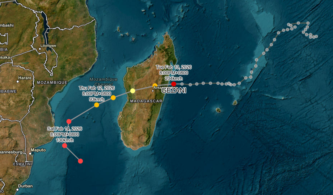
No immediate reports of fatalities emerged by February 11, but the storm’s path through populated areas suggests significant risks. Previous cyclones in the region have led to substantial humanitarian needs, including displacement and infrastructure strain.
Impact Assessment
The cyclone’s high winds caused potential structural damage in coastal areas, with storm surge reaching 1-2 meters (3-7 feet) along the east-central coast.
Torrential rains triggered life-threatening flash floods and river overflows, exacerbating vulnerabilities in regions still recovering from Cyclone FYTIA.
Approximately 13,000 schools, 1,800 health units, and 800 km (500 miles) of electricity networks in Mozambique are at risk from the system’s potential re-intensification. In Madagascar, the Atsinanana region faced the brunt, with disrupted transportation and power expected.
Humanitarian risks remain high, with flash floods and mudslides likely due to saturated ground. No confirmed damage assessments are available as of February 11, but early signals indicate severe effects on housing and agriculture.
Official Statements
“Madagascar: Tropical Cyclone GEZANI is expected to make landfall in the Toamasina II district around 6:00pm local time today, February 10. At time of impact, estimated wind gusts could reach 250km/h (155mph). In addition, the storm will generate heavy rainfall of 100 to 150 mm (4 to 6 in) within 24 hours, which could cause widespread flooding, flash floods, and landslides along its path. A deterioration of sea conditions is expected starting this afternoon. Please carefully follow the instructions issued by the local authorities.” (U.S. Department of State Consular Affairs, February 10, 2026).
“The storm could bring winds of up to 120 kilometers per hour, with gusts that could reach 140 kilometers per hour, accompanied by heavy rain.” (Mozambique’s Minister of Public Works, Housing and Water Resources, February 10, 2026).
“Environmental conditions may support further strengthening, and Gezani could become an intense tropical cyclone before reaching Madagascar.” (South African Weather Service, February 10, 2026).
Full Report & Analysis
The full report includes expert analysis and risk assessment.
Full Report & Analysis →